CLIMATE TRENDS REVIEW – 12
NENANA ICE BREAKUP, ALASKA
-
“Climate Trends Review” presents an update or reminder of selected postings that I have made on my Climate Trends blog since 2016. It also amalgamates various separate postings on related subjects.
-
Please use the links to go to the original postings.
UPDATED 13 MAY 2022

Records have been recorded since 1917 of the breakup of river ice in the Tanana River at the town of Nenana in central Alaska. A tripod is placed near the middle of the river each winter opposite the town wharf and the date and time of its collapse is recorded.

Details of the “Nenana Ice Classic”, where people estimate the date and time of the next breakup can be found at: www.nenanaakiceclassic.com/ This website also contains a lot of data about historical ice breakups since 1917. A webcam of the tripod area is at: http://www.borealisbroadband.net

The Tanana River (about 940 km or 580 miles long) is a major tributary of the Yukon River in central Alaska, north of the Alaska Range. Its headwaters are near the Alaska-Yukon border from where it flows in a generally westerly direction, passing south of the city of Fairbanks. About 80 km (55 miles) downstream from the city of Fairbanks is the town of Nenana and the Nenana River tributary.

The Tanana River freezes over in about December and typically achieves an ice thickness at Nenana of 35-50 inches (0.9-1.2 m) by early April. The collapse of the river ice (known as the “breakup”) typically occurs in late April or early May. The breakup usually occurs quite suddenly during the spring thaw and the resulting high river flows. The majority (80%) of breakups occur in the daytime between 9 am and 8 pm.
The 2022 breakup occurred on 2 May.
This post analyses the variation in the date of breakup since 1917. It also presents the variation in ice thickness in each year since 1989 and its relation to the date of river breakup.
ANNUAL BREAKUP DATE TREND


ANNUAL MAXIMUM ICE THICKNESS
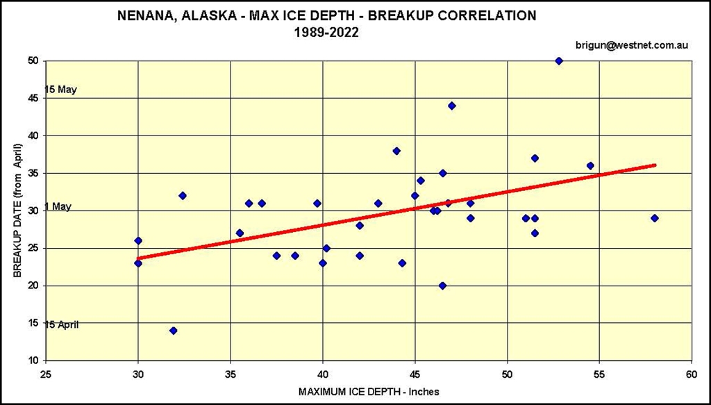
The variation in ice thickness at Nenana has been documented since 1989. The annual maximum thickness is generally in the range of 35-50 inches and no significant trend is seen to have occurred over that (relatively short) 34-year period.
There is a poor correlation between the breakup dates and the maximum ice thicknesses. This suggests that the breakups have other causes, such as springtime floods that rupture the ice cover.

BREAKUP IN INDIVIDUAL YEARS
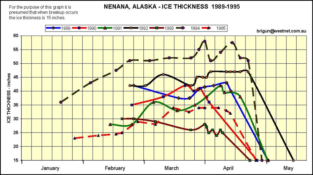
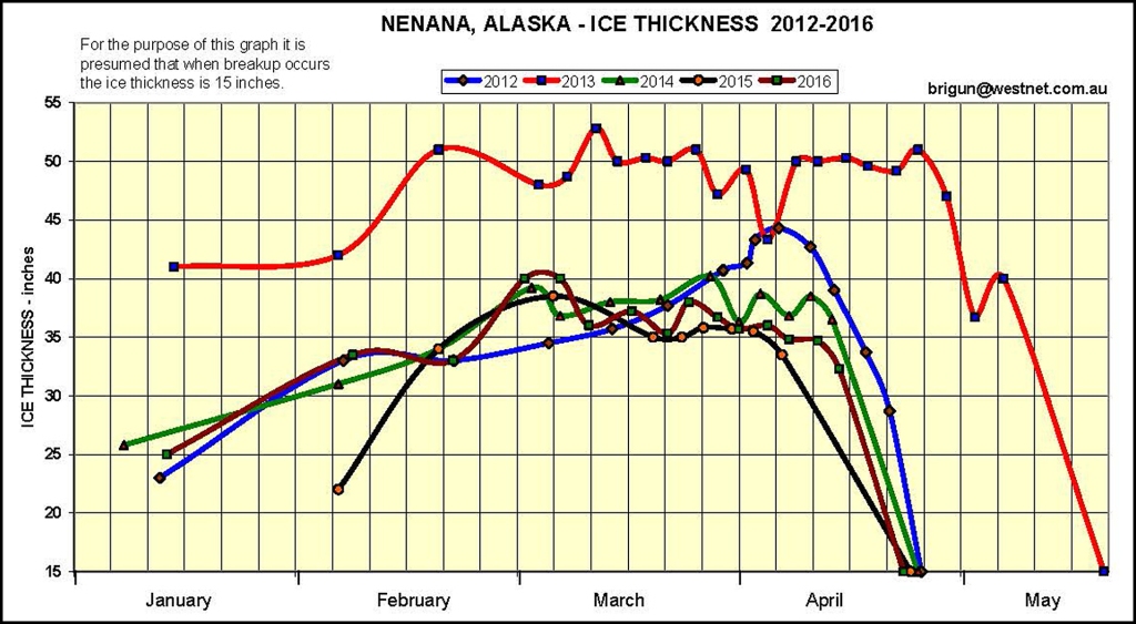
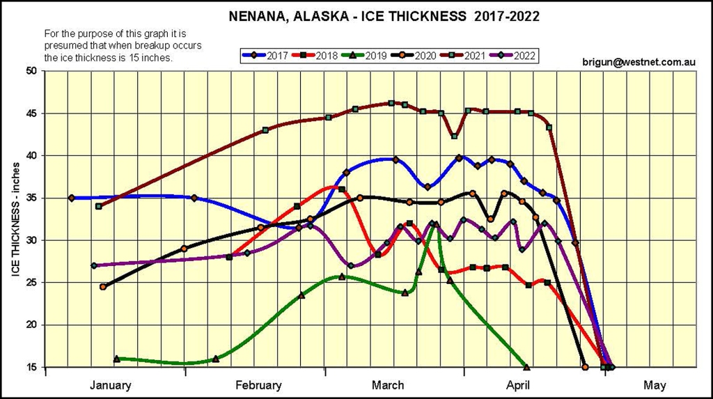
Since 1989 regular measurements of the ice depth at the tripod have been made. These are useful in understanding the variation of ice cover at Nenana during the winter and the sudden breakup in spring.
1989-1995
1996-2001

2002-2006

2007-2011

2012-2016
2017-2022
YUKON RIVER BREAKUP
There is a close correlation with the breakup in the Yukon River at Dawson City, Canada where breakup data are available since 1896.
The Yukon River breakup occurs, on average, 8 to 10 days later than at Nenana.

COMMENTS
– The dates of the annual breakup at Nenana have decreased by about seven days over the past century. However this decrease has not been uniform. Between 1917 and 1970 the average breakup date was 6 May, but since 1970 the average breakup date has been 2 May. This decrease may be due to warmer winters over the past century, or development of the Fairbanks region since 1970 may also have had an influence. Or maybe the Spring temperatures or rainfall have changed over the past century – I must check that out sometime!
– The date of the breakup is almost independent of the maximum thickness of ice during the winter. During the past 34 years, since 1989, the breakup generally occurs (80% of the time) between 28 April and 12 May irrespective of how cold the preceding winter has been. It therefore is suggested that the breakup date is mainly dependent on the rising temperatures in spring (which causes snowmelt) and spring rainfall (which increases the snowmelt and can also produce floods and ice-jams in the rivers).
– The absence of any positive or negative trend in the annual maximum ice thickness indicates that there has been no significant change in the winter climate over the past 34 years. Such a short period, however, is much too short to identify any long-term climate trend.
– There is a good correlation between the breakup dates at Nenana and in the Yukon River at Dawson City (Yukon, Canada). Both locations are within the Yukon River basin, although 470km (290 miles) apart.
ACKNOWLEDGEMENTS
Permission to publish the “2016 Poster” and the webcam image was kindly granted by the Nenana Ice Classic organisation. The “2016 Poster” is the work of Alaskan artist Barbara Lavallee. The webcam image is from an installation of Borealis Broadband.
THE AUTHOR
 This article was written by Brian Gunter from Narooma, NSW. In his previous life Brian was an engineering hydrologist involved over many years in the analysis of rainfall and river flow of data for the planning of major water resources projects in Australia, Asia and Africa. In recent years he has been one of the Marine Rescue NSW (previously Royal Volunteer Coastal Patrol) volunteer weather observers who operate the Narooma station for the Bureau of Meteorology.
brigun2546 (at) gmail.com
Published by
Brian Gunter
Retired civil engineer.
Particularly interested in climate trends.
View all posts by Brian Gunter
